Parks are all about happiness and joy, right? Children play together on the playground, on the tennis courts, on the soccer fields and they all play by the rules, right? Well, sometimes, at least. But before the park itself can even be built, you have to get a bunch of smart adults, and the data they produce, to play together nicely. Which can definitely be difficult when you're dealing with Surveyors, Civil Engineers, and Architects.
Speaking as a girl who comes from a line of Surveyors and became a Civil Engineer, I know that sometimes, even these guys can't get along, let alone trying to add Architects to the mix!
But enough about social issues, let's talk about data. Having all of the data from these disciplines work smoothly together in an AutoCAD-based product (AutoCAD, AutoCAD Architecture, AutoCAD Civil 3D, etc.) depends highly on the drawing units. Let's look at how each of the disciplines usually works with units:
Units
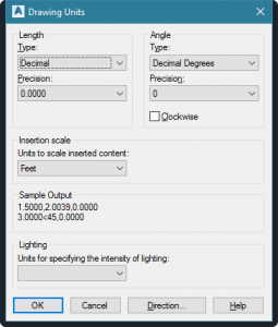
• Surveyor = Feet • Civil Engineer = Feet • Architects = Feet and inchesLooks good, right? Wrong. In order to understand why this isn't good, we need to look at how every AutoCAD-based product views the "units" settings. When you draw a line in AutoCAD with a length of "36", what does that 36 really represent? Is it 36 feet? Is it 36 inches? Or even 36 meters if you're one of the unlucky ones that has to work in metric units. Answer: AutoCAD doesn't know until you tell it. It just draws a line that is 36 units. It doesn't really care what those units are. But YOU care! Which is why there is that "Drawing Units" dialog. Just type in UNITS at the command line, hit and Tada!

See that section in the middle of the dialog that says “Insertion Scale?” The dropdown is labeled as “Units to scale inserted content.” This can confuse people and make them think that this is the units setting for incoming content. While this is true, I find that it's much easier to think of it in the opposite way. This is your opportunity to tell AutoCAD what 1 “unit” actually represents in YOUR drawing. If you draw a line that is 36 "units" and you mean that to be 36 feet, then this drop down needs to say "Feet." Likewise, if you draw something as 36 "units" and you meant that to be 36 inches, then this dropdown needs to say "Inches."
Now perhaps you are one of those people who wants to create a line that is 3 feet, 2 inches long and you type in 3'2 for the length. You might think "hey, I'm working in feet." But the truth is that according to AutoCAD, you're really not. You are working in inches, you are just asking AutoCAD to do the multiplication for you by adding in the ' symbol to indicate what part of your entry is feet. Entering in a length of 3'2 will actually draw a line that is 38 units long. So if you work like this, you need to make sure that the "Insertion Scale" drop-down is actually set to "Inches." This is true whether your "Type" is set to Architectural or Engineering,
Some people want to get around this by just selecting "Unitless" in this drop-down. But trust me when I tell you that this can cause all kinds of problems. Not just for you, but for other people who are trying to work with your drawing. So this is really not recommended.
How can I tell??
If you're not sure what units you should be in, a quick way to find out is to set the Units to "Decimal" and "Unitless," then measure a known length (ex. Football field, sidewalk width, etc.) This will eliminate any automatic calculations or unit markings that were added by the system. For example, if you now use the DIST command to measure a Football field and you get a length of 300, then you can safely conclude that the drawing's originator was working in feet since football fields are 300 feet long from endzone to endzone. If instead you measure this length and it shows up as 3600, then you will know that the drawing was originally created in inches. (Note, If the latter occurs and you set the unit options to "Architectural" and "Inches," then do the DIST measurement again, this value will now be shown as 300'-0".)Bottom line....
It is important to make sure that each drawing you are working with has this setting - the UNITS Insertion Scale - set to correctly represent the units that were used in that drawing. Only then will your drawings be able to automatically scale correctly upon insertion or XREF. Here are some rules of thumb (most-often true, but not always):- If the drawing was originally from an Architect or Landscape architect, this Insertion Units setting will probably need to be "Inches."
- If the drawing was originally from a Surveyor or a Civil Engineer and it is not a detail drawing, this Insertion Units setting will probably need to be "Feet."
- If you do a DIST measurement and the answer is provided in a form of X'-Y," or if you see that the "Length Type" is set to "Architectural" or even "Engineering," then the Insertion Units setting will probably need to be "Inches."
- If a 3.5-foot line can be drawn by entering a length of 3'6, then the Insertion Units setting should be "Inches."
- Setting the Insertion Units to "Unitless" is not recommended for drawings that will be used down the road as blocks and/or XREFs.
